


locheur 12k

UDGI54
User
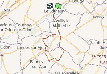

Length
12.2 km

Max alt
158 m

Uphill gradient
223 m
Km-Effort
15.2 km

Min alt
58 m

Downhill gradient
223 m
Boucle
Yes
Creation date :
2020-12-06 10:56:07.945
Updated on :
2020-12-06 10:56:34.379
--
Difficulty : Very easy

FREE GPS app for hiking
 SityTrail
IGN / Geographical institutes
SityTrail Plus
The world is yours!
About
Trail On foot of 12.2 km to be discovered at Normandy, Calvados, Val d'Arry. This trail is proposed by UDGI54.
Positioning
Country:
France
Region :
Normandy
Department/Province :
Calvados
Municipality :
Val d'Arry
Location:
Le Locheur
Start:(Dec)
Start:(UTM)
678648 ; 5441754 (30U) N.
Comments